
Tabla de contenido
Regarding the route for participants in this year’s Boston Marathon, it will cover 26.2 miles or 42.195 kilometers, with a total of 30,000 runners.
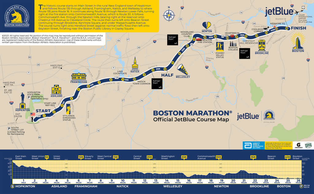
Route and Elevation of the Boston Marathon
The Boston Marathon route will start in downtown Hopkinton, a town on the city’s outskirts. Runners will encounter a mostly flat and downhill path during the first half. However, they should pace themselves, as the second half of the route changes drastically with steep and exhausting inclines. This is especially true at kilometer 32, at the famous ‘Heartbreak Hill,’ which features a challenging 1,400-meter ascent.
Boston Marathon Route Video
Although this hill only stretches 3 kilometers, it demands high endurance and strength. Once the peaks and high elevations are behind them, the final 7 kilometers will be downhill, leading to the finish line on Hereford Street by the sea.
Below is a table with each mile’s elevation changes in meters and feet.
Boston Marathon Route Elevation
BOSTO MARATHON ELEVATION
Here you will find information on the famous Boston Marathon hills:
Boston Marathon Hills
| Hill Name | Location (km) | Length | Ascent |
|---|---|---|---|
| Hill 1 | 25.6 km | 969 meters | 22.9 meters |
| Hill 2 | 28.2 km | 480 meters | 22.6 meters |
| Hill 3 | 30.7 km | 640 meters | 19.2 meters |
| Heartbreak Hill | 32.5 km | 640 meters | 29.6 meters |
Aid Stations
Hydration stations are located at every mile marker along the course and at the finish line. Although the marathon is considered one of the toughest, it cannot set a world record because certification rules prohibit a course where the finish line is at a lower altitude than the start, which is a crucial feature of this route.
Aid stations along the course close at staggered times throughout the day. The ones near the finish area close officially around 5:30 p.m.
Boston Marathon Elevation Markers
Digital clocks display unofficial times every 5 kilometers starting at 9:00 a.m. only. Signage indicates mile markers and 5K distances.
If a runner cannot finish the race, they can stop for assistance at one of the 26 medical stations along the course. Sweep buses will pick up runners at each medical station and transport them to the medical tent at the finish area.
Download the route in .GPX format, forecast, and time calculator for the Boston Marathon
You can download the Boston Marathon route in .GPX format, forecasts, and a time calculator are here: Running.COACH Calendar.
Create a personalized and dynamic training plan with running.COACH that optimally prepares you for your race goals based on your current fitness level, including recovery runs. Try running.COACH for free for fifteen days after your first login!

Looking for a plan that trains with you, not against you?
At running.COACH, we don’t just build a schedule. We create a smart, living plan that evolves with you. It understands your level, your race goals and your real life. Whether you sync your GPS watch or train straight from our iOS or Android app, your plan adjusts automatically as you improve.
From day one, you’ll feel the difference:
- A fully personalized, dynamic plan designed for you.
- Automatic sync and effortless workout tracking.
- Real-time updates when life happens, including missed sessions, new races or schedule changes.
- Simple, science-backed guidance to train smarter and recover faster.
🎁 Start today and enjoy your first 30 days free.
Because the best training plan isn’t one you follow. It’s one that follows you.app.


0 Comments