Tabla de contenido
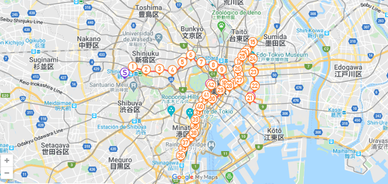
The Tokyo Marathon, which this year takes place on Sunday, March 2, 2025 (Japan), debuted a new route in 2017. Since then, it has represented a journey that symbolizes the city’s past, present, and future.
Map of the Tokyo Marathon route
Although not completely flat, the climbs and descents are gentle, making it a fast and attractive race for elite runners and amateurs looking to improve their time.
Course Altimetry:
- Predominantly flat: Most of the course is flat, with few significant elevations or slopes.
- Gentle elevation: The small climbs are short and not too steep, which does not significantly affect the pace.
- Maximum elevation: There are no drastic changes in altitude. The biggest climb occurs at the start of the race in the Shinjuku area, but it is slight.
- Gradual descent: Throughout the course, the profile tends to descend slightly towards the Imperial Palace area and the finish at Tokyo Station, which helps runners maintain a good pace in the second half of the race.

n the beginning, the Tokyo Marathon route runs through the old town, then through the more modern downtown and then through the most futuristic route in the city.
Historic places on the Tokyo Marathon route
The marathon finishes near Tokyo Station in the Marunouchi district, a major financial and business center.
Start: In front of the Tokyo Metropolitan Government Building (Shinjuku)
The race starts in the Shinjuku area, a major commercial and government district known for its skyscrapers and vibrant urban life.
Important points along the route:
Sensoji Temple: Runners pass near the famous Sensoji Temple, one of the most touristic places in Tokyo.
Imperial Palace: The route takes runners through the area near the Imperial Palace, home of the Japanese imperial family, a key historical and cultural point.
Tokyo Tower: Although not a direct part of the course, many runners can see the iconic Tokyo Tower in the distance.
Tokyo Skytree: This is the highest point on the course from which runners can enjoy a breathtaking view.
Finish: Tokyo Station (Marunouchi)
This video shows the current Tokyo Marathon route
Download the route in .GPX format, forecast, and time calculator for the Tokyo Marathon route
If you want to download the Tokyo Marathon route in GPX format, visit running.COACH Calendar.
If you want to train for the Tokyo Marathon, follow a plan that takes into account the altitude and course of the race. Be sure to try running.COACH.
Create a dynamic, personalized training plan with running.COACH that optimally prepares you for your running goals based on your current fitness level – including recovery runs. Try running.COACH for free for 15 days after your first login.
Looking for a plan that trains with you, not against you?
At running.COACH, we don’t just build a schedule. We create a smart, living plan that evolves with you. It understands your level, your race goals and your real life. Whether you sync your GPS watch or train straight from our iOS or Android app, your plan adjusts automatically as you improve.
From day one, you’ll feel the difference:
- A fully personalized, dynamic plan designed for you.
- Automatic sync and effortless workout tracking.
- Real-time updates when life happens, including missed sessions, new races or schedule changes.
- Simple, science-backed guidance to train smarter and recover faster.
🎁 Start today and enjoy your first 30 days free.
Because the best training plan isn’t one you follow. It’s one that follows you.app.


0 Comments